Knowledge is power. With the information now available at the fingertips of planners, traffic engineers and public safety professionals, more powerful methods are on the horizon to keep drivers, passengers, pedestrians, bicyclists and others safe.
If the insurance industry exploits this new trove of knowledge, the result can be fewer accidents, further declines in injuries and fatalities and a reduction in liability for everyone.
This new era in data-driven solutions can’t come fast enough. Globally, approximately 1.4 million people die in road crashes every year, or more than 3,700 each day, according to the Association for Safe International Road Travel. The Insurance Information Institute reports that speed-related crashes cost Americans $40.4 billion every year. Meanwhile, distracted driving continues to be a growing issue; in the latest Traffic Safety Culture Index report from AAA’s Foundation for Traffic Safety, more than half of drivers (52%) admitted driving while talking on a handheld cellphone at least once within the prior 30 days.
Traffic modeling used by departments of transportation is brittle and in need of updating. COVID-19 has contributed to this issue by forcing driving habits that will likely remain permanent. Commuting patterns and volumes have changed—and, with fewer cars, higher traffic speeds occur. On the urban planning side, concepts like parklets and bicycle lanes are taking hold; yet planners often work with 30-year-old data, along with parameters that are woefully behind the times.
A New Era in Data Analytics
Using data to increase vehicular and pedestrian safety is nothing new—but historically it’s had limitations. Traditionally, roadway data has been heavily aggregated from a limited number of sources. Road counters, for example, would give professionals traffic counts that amounted to a snapshot in time.
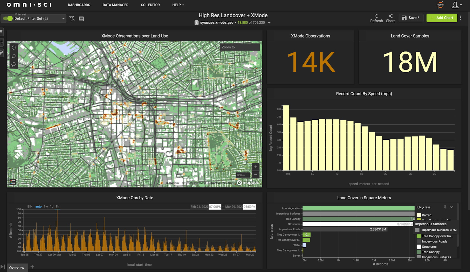
Geospatial data, by contrast, adds multiple dimensions to the art of ensuring safer roads, safer pedestrians and safer drivers. The most important change is that experts are now able to do analytics on disaggregated, granular data. Geospatial researchers are able to collect billions of records every month—not only traffic data but road conditions, event activity, accidents, weather, even what happens to vehicles as they move across networks. The science provides continuous, systematic visibility of factors over time and space.
By isolating, combining and cross-analyzing such massive datasets over time, researchers can investigate factors that play important roles. Police officers, for example, write reports hours after an accident has occurred, making accounts of road conditions at the time of the accident subjective. Through the use of continuous weather tracking, it’s now possible to roll back the data and pinpoint the impact of precipitation, fog, etc. to the very moment of collision.
See also: Free Insurance Data You’ll Need
Technology is making it possible to improve traffic safety in ways unimaginable just a few short years ago. Accelerated geospatial analytics allows analysts and planners to ask questions, and draw conclusions, from billions of lines of data, receiving those answers in milliseconds. This transformative capability lets professionals plot and visualize results, even for small or isolated areas.
Today, it’s practical to see how traffic is not only behaving in a single area, but also at the impact of different modes. Planners can investigate pedestrian activity, weather and other variables. If accident data causes engineers to look at a particular intersection, they can see the activity patterns around that intersection by time of day, day of week, holidays, commuting periods, even after a football game or other surge event.
The real-time component of geospatial analytics can be a game changer. Instant data, viewable nearly as soon as it’s collected, helps public safety departments plan their responses. In Austin, Texas, police, safety and repair crews were pre-positioned before a recent major rainstorm; the real-time analysis of changing flood patterns based on elevations, storm mitigation infrastructure, etc., was intersected with roadway maps to minimize accidents and damage. When public safety departments have knowledge of the street-to-street impact on traffic during sporting events, concerts, even public demonstrations or protests, the benefits to pedestrian and traveler safety can be remarkable.
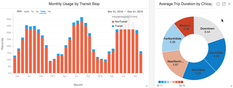
Accelerated analytics also helps with forecasting. Trends in bike sharing is one way to gain a better understanding of how to redo a street. This kind of insight into shifting transportation modes, particularly in urban areas, can be a major help to planners who have to think not in terms of months or even years, but decades.
New analytics platforms with accelerated processing capabilities make it possible to achieve all these benefits, all within the same tool. Moreover, there are few barriers to adoption. Advanced geospatial platforms are based on GIS (graphic information system) standards, making it easy for conventionally-trained GIS pros to quickly get up to speed. On the hardware side, advanced processing capabilities may be needed, but that can be acquired as a cloud-based service at reasonable cost.
Cooperation Is Increasing
Scores of organizations and industry partners are working together to make the most of the revolution in geospatial data. The Safe Streets Initiative, among others, is helping to change the way professionals understand the human behavioral aspects of traffic management.
It used to be taken for granted that the safest way to plan roadways was to make everything straight, with wide rights-of-way and huge clearances. Today, planners know that such approaches cause people to race through an area, making travel more dangerous instead of safer. Street design, too, takes into account a great deal of contextual information about street surfaces, pedestrian movement, retail density and patterns, as well as alternative modes such as electric scooters. What works on one block may be counterproductive two blocks away — something that the human element often makes clear.
Another issue is the evolving nature of transportation. The rise of ride-sharing is causing planners to look for ways to support stops to pick up passengers without affecting safety. Electric cars, scooters and bikes are affecting design guidelines, as well, making standards from just a few years ago obsolete.
Perhaps most important to geospatial analytics is the way data partners are coming together. Participation varies widely and often involves negotiation, but many partners are stepping up their game. Electric scooter data, for instance, is widely available, and electric bike sharing businesses usually include data sharing in their agreements with municipalities.
A key benefit — yet in some respects, a drawback — of all this granular data is the massive datasets. Uber releases Transportation Analysis Zone (TAZ) data from its operations, which is immensely useful for broad-scale transportation planning, but the benefits of TAZ are less useful for design work because there can be a huge diversity of conditions within one TAZ. As a result, there is opportunity for new methods of identifying analysis units; real-time GPS telemetry might reveal large numbers of pedestrians and cars mixing in an area along with electric scooters, indicating the need for specific planning solutions.
Need for Carrier Involvement
There is a role for the insurance industry in advancing geospatial analytics. Carriers should consider doing some active data-sharing pilot projects that allow experts to not only get hands-on experience but also evaluate how systems work together. Best practices are still emerging, including how insurance data can integrate with other sources. Determining how those combinations can be analyzed in real time is something new for practitioners to consider.
Many concepts can be applied to these integrated datasets. Cohort analysis, a common technique that allows data about specific groups to be tracked through time, is nonetheless rarely used in transportation planning. This is a huge opportunity, as is the use of machine learning and artificial intelligence to identify present and future trends in cross-referenced data.
Pilot projects can be done in an agile manner, flexibly and at low-cost. Insurance companies should find ways to empower internal teams and departments to investigate and find new solutions that will benefit policyholders, safety professionals, transportation providers and the general public.
See also: The End of Auto Insurance
The Future Is Happening
When public and private entities combine forces to improve society, good things typically result — and transportation safety is no exception. From improving traffic safety in an urban corridor and accommodating new forms of travel, to lowering instances of distracted driving and reducing fatalities, data sharing is a pathway to new insights and better solutions.
There is a fundamental need to update the cadence and the granularity of the most basic data about travel behavior, in all its forms. Geospatial analytics can be the engine that drives this new capability. Knowledge is power — and with the power of geospatial capabilities behind their design, our streets and highways can be safer and more intelligently designed than ever before.