
The spring before each hurricane season brings with it calls for preparation throughout those who live on or near coastal areas, as well as throughout the (re)insurance industry. To aid in anticipating such preparations, professional forecasters in academia and industry have been releasing their preseason forecasts for the coming Atlantic hurricane season for decades. These forecasts are based on statistical and climatological models built up from past seasons’ activity and accompanying large-scale climatological patterns. As the science behind these models has improved, these forecasts have become more skilled. With the Atlantic hurricane season just starting, let's examine these preseason predictions for the 2024 season and the science behind them.
See also: Preparing for a Rough Hurricane Season
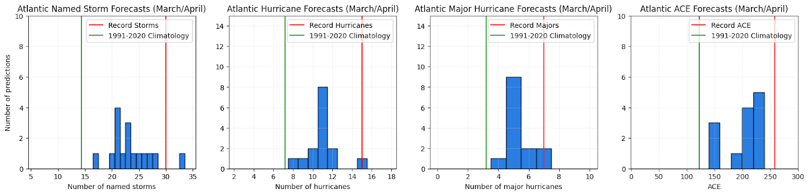
Figure 1- Histograms of the 18 preseason (March/April) forecasts for named storms, hurricanes, major hurricanes and accumulated cyclone energy (left to right) compiled by the Barcelona Supercomputer Center and Colorado State University forecasters. The green line represents the recent average for that category; the red is the historical record for that category.
This season’s forecasts for Atlantic hurricane activity from 18 preseason forecasters are noted in Figure 1’s histograms. From these, we see that the forecasters are predicting that the Atlantic will be busy this year, with most forecasts lying between 20 and 25 named storms, 10 to 12 hurricanes, four to six major hurricanes and an accumulated cyclone energy (ACE; an integrated measure of the activity in a season) between 150 and 240 units. These forecasts are all above the recent averages of 14 named storms, seven hurricanes, three major hurricanes and 120 units of ACE.
See also: The Hurricane Forecast Keeps Getting Darker
These forecasters all use a variety of climatological patterns to guide their forecasts, though many are built around some combination of the same two primary factors: how warm the Atlantic sea surface temperatures will be and the state of the El Niño Southern Oscillation (ENSO). These two factors have been found to be the strongest statistical predictors of Atlantic hurricane activity.
Sea surface temperatures are the simplest effects to understand. Hurricanes form due to strong thunderstorms organizing and forcing a warm-core vortex. This is best accomplished with vigorous, persistent and upright thunderstorms. Warmer sea surface temperatures mean more energy and more moisture being pulled upward through these thunderstorms. So, in general, warmer sea surface temperatures mean that more tropical storms will likely form throughout the course of a season.
ENSO is a bit more complex. ENSO is a coupled ocean-atmosphere climatological mode, measured by the variations from the climatological averages for the waters in the tropical central Pacific Ocean. If these waters are warm/cold, ENSO is in an El Niño/La Niña phase. The phase of ENSO is reflected in the atmosphere by the changes in the overturning tropical circulation worldwide, known as the Walker circulation. For the Atlantic, when El Niño is active, the wind shear in the Caribbean Sea and central Atlantic tends to be increased. When La Niña is active, shear is typically decreased. As mentioned previously, vertically upright thunderstorms best form a tropical storm vortex, so less shear means that more storms will tend to form and intensify.