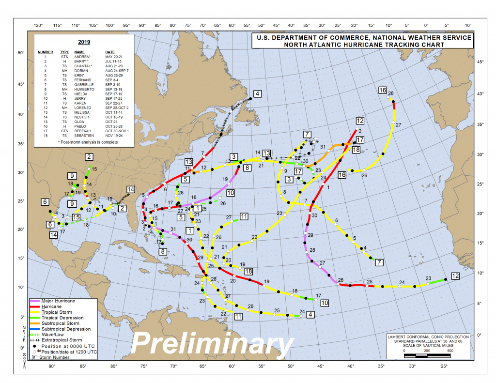
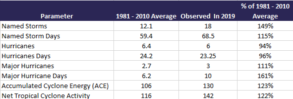
The six-month 2019 North American hurricane season is officially in the books, and it was an active one in terms of named storm counts, with the majority of activity coming in the typical mid-August and mid-October periods. The season ended with 18 named storms, six of which became hurricanes, and three of those achieving major hurricane status (Category 3+ on the Saffir-Simpson scale). Having 18 named storms in a season is well above the 12.1 average (1981 – 2010), but the number of hurricanes and major hurricanes is right around what would be expected in an average year. In terms of ACE (Accumulated Cyclone Energy), the season ended up at 123% of the average, with two storms, Dorian and Lorenzo, contributing an impressive 61% to the tally.
[caption id="attachment_37446" align="alignnone" width="570"] Preliminary Atlantic Tropical System Track Map Source: NHC.[/caption]
[caption id="attachment_37447" align="alignnone" width="586"] Key parameters that track the overall activity during a hurricane season. Source: NHC and Colorado State University[/caption]
What is, perhaps, even more interesting is that, of the 18 named storms, eight of them lasted two days or less, and some didn’t even last 24 hours. Two storms (Olga and Imelda) ended up being named storms for only six hours. The number of named storm days totaled 68.5, which is 115% of the expected 59.5 average (1981 – 2010). This year clearly showed the bias to satellite observations, as several of the named storms this year likely would not have been named in the pre-satellite era.
Even these short named storms can be destructive to the insurance industry, such as Imelda, which hit parts of eastern Texas with 43 inches of rainfall. This highlights that the category is not always indicative of how destructive a hurricane might be. In fact, the named tropical storms of Imelda, Nestor and Olga accounted for 42% of the total U.S. insurance industry loss this season, which should likely ultimately settle for under $2 billion. The named storm average annual loss for the U.S. is over $15 billion annually, so the U.S. insurance industry was lucky this year, especially considering Dorian.
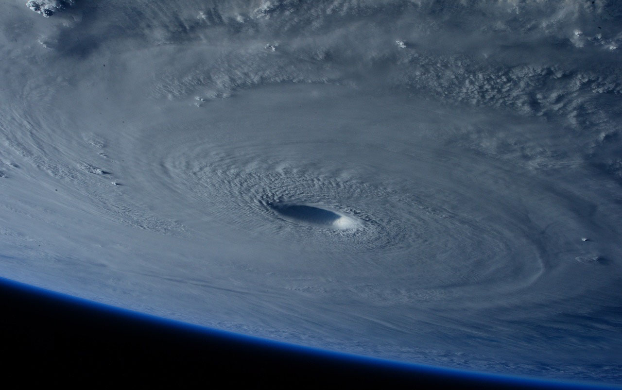
The season will clearly be remembered for major hurricane Dorian, which stalled over the northern Bahamas as a Category 5 hurricane for nearly two days and gave south Florida a good scare when the monster storm refused to leave the area. The insured loss impacts to the Bahamas are expected to surpass $3.5 billion. Even though the strongest winds remained off the coast of the U.S., impacts were still felt in Florida, Georgia, South Carolina and North Carolina (but not Alabama). This will be the largest insured loss event for the U.S. this season, at over $500 million.See also: Grasping the Perils of Extreme Weather
We also can’t forget about Dorian’s impact to eastern Canada, which is expected to hit around $2 billion (CAD) of loss and had a wide-ranging impact. This is a good reminder that strong named storms can easily affect New England during a hurricane season. With saturated ground and trees being in full leaf, many large trees were uprooted across eastern Canada, leading to long-term power outages, a major source of loss after strong wind events. Around 80% of the homes and businesses lost power in Nova Scotia at one point, a reminder that the insurance industry can easily suffer losses from long-term business interruption payments.
How Lucky
I’m not sure if the worldwide insurance industry truly understands the bullet that was dodged this hurricane season, as we saw the most intense hurricane to ever hit the Bahamas, which also tied the record with the 1935 Labor Day hurricane for the strongest landfall anywhere in the Atlantic. hurrThe losses could have easily reached $75 billion of insured loss and maybe more. The winds alone would have caused considerable damage to almost every single insured property in southeast Florida. The storm surge and flooding rains would have likely had a major impact on the National Flood Insurance Program and many of the new private markets now writing flood business in Florida. Even with 11 consecutive years (2006 – 2016) of no major hurricane catastrophes in Florida, there have been other loss issues across the state that have already strained parts of the market. Such a catastrophic event at this time would have been a big stress test for the Florida Hurricane Catastrophe Fund, considering such a Dorian-type event would be near the 100-year to 250-year event that many companies plan for on a yearly basis.
The other noteworthy (positive) impacts on the insurance industry might be the huge void of hurricane activity in the Caribbean Sea and Gulf of Mexico. In fact, only hurricanes Dorian and Barry reached hurricane-strength in those areas, which again is welcome news for the insurance industry. It always amazes me when a named storm can hit the tiny insurance hub of Bermuda, which happened this year with Hurricane Humberto.
A look ahead to 2020:
It’s way too early to make predictions for the 2020 Atlantic hurricane season, but some of the climate forcers to think about for 2020 are listed below.
See also: Risks, Opportunities in the Next Wave
*El Niño Southern Oscillation (ENSO) is currently in a neutral state and is forecasted to stay there for the beginning of the 2020 Atlantic Hurricane Season. If this is the case, neither La Niña nor El Niño will have a large influence on wind shear or storm tracks.
[caption id="attachment_37448" align="alignnone" width="570"] IRI ENSO forecast model Based Probability showing Neutral ENSO Conditions next hurricane season July August September (JAS)[/caption]
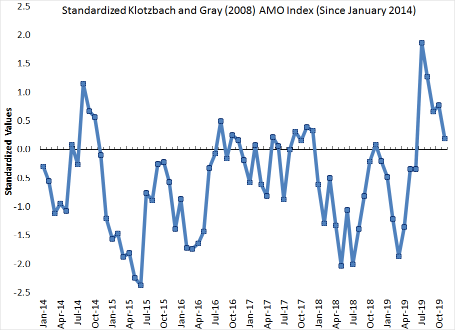
*After spiking this summer, the Atlantic Multidecadal Oscillation (AMO) index dipped back to near average in November, according to the Klotzbach and Gray AMO index, as far north Atlantic sea surface temperatures are currently near their long-term average values. This could have explained the higher activity this season and could lead to lower counts next season if sea surface temperatures continue to drop.
[caption id="attachment_37449" align="alignnone" width="570"] After spiking this summer, the Atlantic Multi-decadal Oscillation (AMO) index dipped back to near average in November.[/caption]
*Madden-Julian Oscillation, which is associated with an upper-air wave that moves across the tropics every 30 to 60 days, will continue to drive periods of activity in 2020. It is important to watch these waves move from the western Pacific into the eastern Pacific, as they will ultimately help named storm formation in the Atlantic Ocean.
Get Involved
Our authors are what set Insurance Thought Leadership apart.
Andrew Siffert is vice president and senior meteorologist within BMS Re U.S. catastrophe analytics team. He works closely with clients to help them manage their weather-related risks through catastrophe response, catastrophe modeling, product development and scientific research and education.

 Preliminary Atlantic Tropical System Track Map Source: NHC.[/caption]
 Key parameters that track the overall activity during a hurricane season. Source: NHC and Colorado State University[/caption]
What is, perhaps, even more interesting is that, of the 18 named storms, eight of them lasted two days or less, and some didn’t even last 24 hours. Two storms (Olga and Imelda) ended up being named storms for only six hours. The number of named storm days totaled 68.5, which is 115% of the expected 59.5 average (1981 – 2010). This year clearly showed the bias to satellite observations, as several of the named storms this year likely would not have been named in the pre-satellite era.
Even these short named storms can be destructive to the insurance industry, such as Imelda, which hit parts of eastern Texas with 43 inches of rainfall. This highlights that the category is not always indicative of how destructive a hurricane might be. In fact, the named tropical storms of Imelda, Nestor and Olga accounted for 42% of the total U.S. insurance industry loss this season, which should likely ultimately settle for under $2 billion. The named storm average annual loss for the U.S. is over $15 billion annually, so the U.S. insurance industry was lucky this year, especially considering Dorian.
The season will clearly be remembered for major hurricane Dorian, which stalled over the northern Bahamas as a Category 5 hurricane for nearly two days and gave south Florida a good scare when the monster storm refused to leave the area. The insured loss impacts to the Bahamas are expected to surpass $3.5 billion. Even though the strongest winds remained off the coast of the U.S., impacts were still felt in Florida, Georgia, South Carolina and North Carolina (but not Alabama). This will be the largest insured loss event for the U.S. this season, at over $500 million.
See also: Grasping the Perils of Extreme Weather
We also can’t forget about Dorian’s impact to eastern Canada, which is expected to hit around $2 billion (CAD) of loss and had a wide-ranging impact. This is a good reminder that strong named storms can easily affect New England during a hurricane season. With saturated ground and trees being in full leaf, many large trees were uprooted across eastern Canada, leading to long-term power outages, a major source of loss after strong wind events. Around 80% of the homes and businesses lost power in Nova Scotia at one point, a reminder that the insurance industry can easily suffer losses from long-term business interruption payments.
How Lucky
I’m not sure if the worldwide insurance industry truly understands the bullet that was dodged this hurricane season, as we saw the most intense hurricane to ever hit the Bahamas, which also tied the record with the 1935 Labor Day hurricane for the strongest landfall anywhere in the Atlantic. hurrThe losses could have easily reached $75 billion of insured loss and maybe more. The winds alone would have caused considerable damage to almost every single insured property in southeast Florida. The storm surge and flooding rains would have likely had a major impact on the National Flood Insurance Program and many of the new private markets now writing flood business in Florida. Even with 11 consecutive years (2006 – 2016) of no major hurricane catastrophes in Florida, there have been other loss issues across the state that have already strained parts of the market. Such a catastrophic event at this time would have been a big stress test for the Florida Hurricane Catastrophe Fund, considering such a Dorian-type event would be near the 100-year to 250-year event that many companies plan for on a yearly basis.
The other noteworthy (positive) impacts on the insurance industry might be the huge void of hurricane activity in the Caribbean Sea and Gulf of Mexico. In fact, only hurricanes Dorian and Barry reached hurricane-strength in those areas, which again is welcome news for the insurance industry. It always amazes me when a named storm can hit the tiny insurance hub of Bermuda, which happened this year with Hurricane Humberto.
A look ahead to 2020:
It’s way too early to make predictions for the 2020 Atlantic hurricane season, but some of the climate forcers to think about for 2020 are listed below.
See also: Risks, Opportunities in the Next Wave
*El Niño Southern Oscillation (ENSO) is currently in a neutral state and is forecasted to stay there for the beginning of the 2020 Atlantic Hurricane Season. If this is the case, neither La Niña nor El Niño will have a large influence on wind shear or storm tracks.
[caption id="attachment_37448" align="alignnone" width="570"]
Key parameters that track the overall activity during a hurricane season. Source: NHC and Colorado State University[/caption]
What is, perhaps, even more interesting is that, of the 18 named storms, eight of them lasted two days or less, and some didn’t even last 24 hours. Two storms (Olga and Imelda) ended up being named storms for only six hours. The number of named storm days totaled 68.5, which is 115% of the expected 59.5 average (1981 – 2010). This year clearly showed the bias to satellite observations, as several of the named storms this year likely would not have been named in the pre-satellite era.
Even these short named storms can be destructive to the insurance industry, such as Imelda, which hit parts of eastern Texas with 43 inches of rainfall. This highlights that the category is not always indicative of how destructive a hurricane might be. In fact, the named tropical storms of Imelda, Nestor and Olga accounted for 42% of the total U.S. insurance industry loss this season, which should likely ultimately settle for under $2 billion. The named storm average annual loss for the U.S. is over $15 billion annually, so the U.S. insurance industry was lucky this year, especially considering Dorian.
The season will clearly be remembered for major hurricane Dorian, which stalled over the northern Bahamas as a Category 5 hurricane for nearly two days and gave south Florida a good scare when the monster storm refused to leave the area. The insured loss impacts to the Bahamas are expected to surpass $3.5 billion. Even though the strongest winds remained off the coast of the U.S., impacts were still felt in Florida, Georgia, South Carolina and North Carolina (but not Alabama). This will be the largest insured loss event for the U.S. this season, at over $500 million.
See also: Grasping the Perils of Extreme Weather
We also can’t forget about Dorian’s impact to eastern Canada, which is expected to hit around $2 billion (CAD) of loss and had a wide-ranging impact. This is a good reminder that strong named storms can easily affect New England during a hurricane season. With saturated ground and trees being in full leaf, many large trees were uprooted across eastern Canada, leading to long-term power outages, a major source of loss after strong wind events. Around 80% of the homes and businesses lost power in Nova Scotia at one point, a reminder that the insurance industry can easily suffer losses from long-term business interruption payments.
How Lucky
I’m not sure if the worldwide insurance industry truly understands the bullet that was dodged this hurricane season, as we saw the most intense hurricane to ever hit the Bahamas, which also tied the record with the 1935 Labor Day hurricane for the strongest landfall anywhere in the Atlantic. hurrThe losses could have easily reached $75 billion of insured loss and maybe more. The winds alone would have caused considerable damage to almost every single insured property in southeast Florida. The storm surge and flooding rains would have likely had a major impact on the National Flood Insurance Program and many of the new private markets now writing flood business in Florida. Even with 11 consecutive years (2006 – 2016) of no major hurricane catastrophes in Florida, there have been other loss issues across the state that have already strained parts of the market. Such a catastrophic event at this time would have been a big stress test for the Florida Hurricane Catastrophe Fund, considering such a Dorian-type event would be near the 100-year to 250-year event that many companies plan for on a yearly basis.
The other noteworthy (positive) impacts on the insurance industry might be the huge void of hurricane activity in the Caribbean Sea and Gulf of Mexico. In fact, only hurricanes Dorian and Barry reached hurricane-strength in those areas, which again is welcome news for the insurance industry. It always amazes me when a named storm can hit the tiny insurance hub of Bermuda, which happened this year with Hurricane Humberto.
A look ahead to 2020:
It’s way too early to make predictions for the 2020 Atlantic hurricane season, but some of the climate forcers to think about for 2020 are listed below.
See also: Risks, Opportunities in the Next Wave
*El Niño Southern Oscillation (ENSO) is currently in a neutral state and is forecasted to stay there for the beginning of the 2020 Atlantic Hurricane Season. If this is the case, neither La Niña nor El Niño will have a large influence on wind shear or storm tracks.
[caption id="attachment_37448" align="alignnone" width="570"]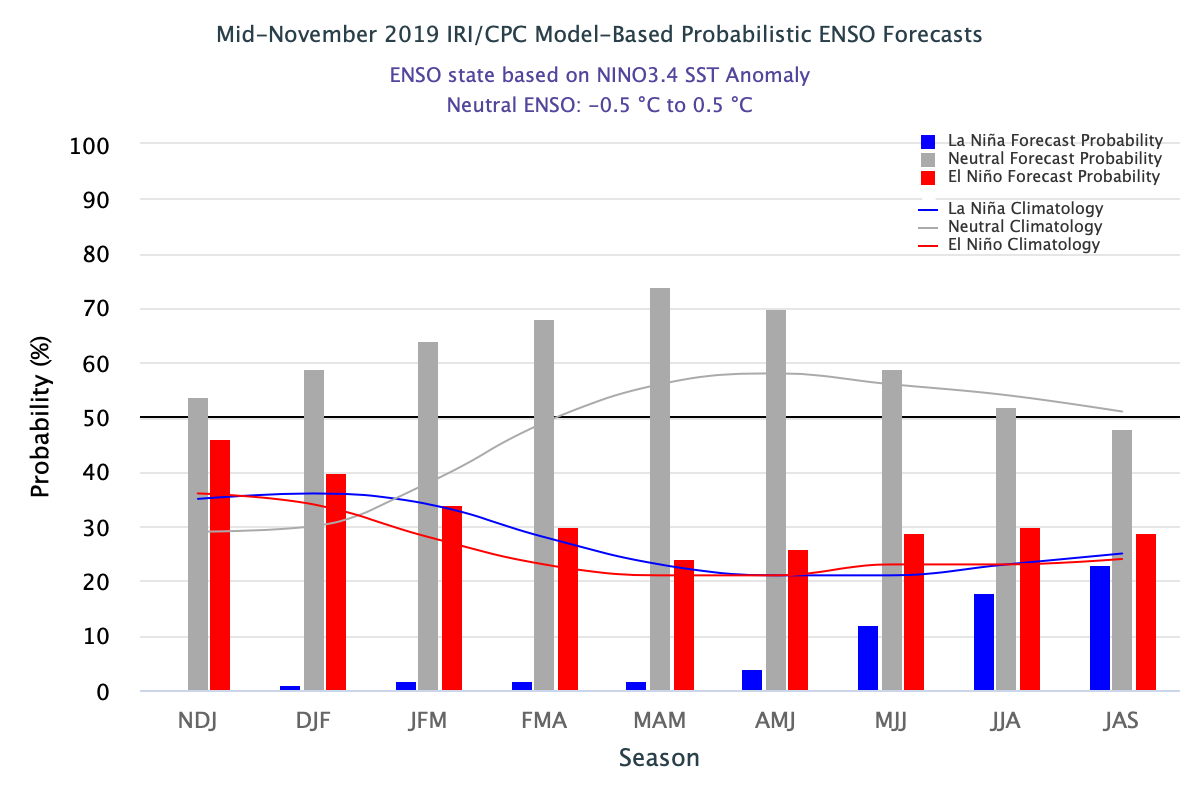 IRI ENSO forecast model Based Probability showing Neutral ENSO Conditions next hurricane season July August September (JAS)[/caption]
 After spiking this summer, the Atlantic Multi-decadal Oscillation (AMO) index dipped back to near average in November.[/caption]
*Madden-Julian Oscillation, which is associated with an upper-air wave that moves across the tropics every 30 to 60 days, will continue to drive periods of activity in 2020. It is important to watch these waves move from the western Pacific into the eastern Pacific, as they will ultimately help named storm formation in the Atlantic Ocean.
After spiking this summer, the Atlantic Multi-decadal Oscillation (AMO) index dipped back to near average in November.[/caption]
*Madden-Julian Oscillation, which is associated with an upper-air wave that moves across the tropics every 30 to 60 days, will continue to drive periods of activity in 2020. It is important to watch these waves move from the western Pacific into the eastern Pacific, as they will ultimately help named storm formation in the Atlantic Ocean.